Difference between revisions of "Inyokern"
Jump to navigation
Jump to search
(Added category.) |
|||
| (2 intermediate revisions by one other user not shown) | |||
| Line 10: | Line 10: | ||
**Approach: 133.65 | **Approach: 133.65 | ||
| − | + | ==Charts and maps== | |
| − | *[http://skyvector.com/?ll=35.658002,-117.828635&chart=301&zoom= | + | *[http://skyvector.com/?ll=35.658002,-117.828635&chart=301&zoom=1 Chart from skyvector.com] |
| − | + | *[http://flttrack.fltplan.com/AirportDiagrams/KIYKapt.jpg diagram from http://www.fltplan.com/AirportInformation/IYK.htm] | |
==External links== | ==External links== | ||
*[http://airportnavfinder.com/airport/KIYK/#com http://airportnavfinder.com/airport/KIYK/#com] | *[http://airportnavfinder.com/airport/KIYK/#com http://airportnavfinder.com/airport/KIYK/#com] | ||
| + | [[Category: Articles]] | ||
[[Category:Surface bases]] | [[Category:Surface bases]] | ||
[[Category:USA]] | [[Category:USA]] | ||
{{Stub}} | {{Stub}} | ||
Latest revision as of 12:11, 14 October 2022
Inyokern Airport (IATA: IYK, ICAO: KIYK, FAA LID: IYK) is a public use airport located in Kern County, California, United States.
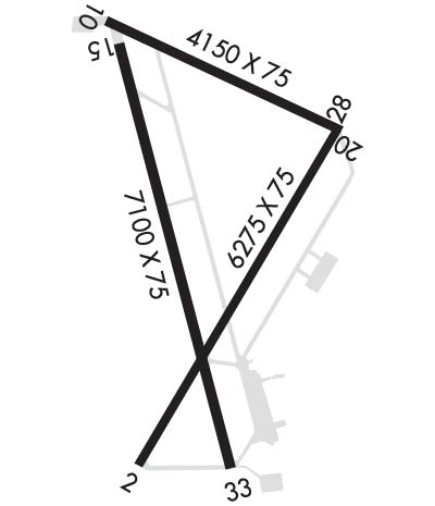
Runways and frequencies[edit]
- It has three asphalt paved runways:
- 15/33, 2164 x 23 m
- 2/20, 1913 x 23 m
- 10/28, 1265 x 23 m
- Frequencies:
- CTAF/UNICOM : 122.8
- Approach: 133.65
Charts and maps[edit]
External links[edit]